

RESIDENTIAL PROJECT MAPS
This page contains links to three maps. Map & project information is subject to change; check with the Planning Department for current info.
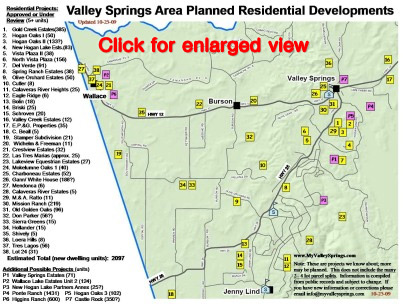
The first map, ‘Valley Springs Area Planned Residential Developments’, was compiled by MyValleySprings.com and contains residential project/owner names, approximate location, and number of new dwelling units. This map was begun in 2005 and is updated as time allows. It covers residential parcel splits of 5 or more units.
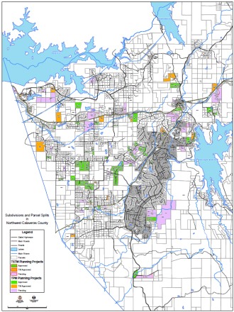
The second map, 'Subdivisions and Parcel Splits in Northwest Calaveras County', was compiled by the Calaveras County Planning Department in May 2011 and contains project numbers, number of lots proposed, exact parcel locations, and project status (approved or pending). This map shows all parcel splits (2 or more) and includes some commercial projects.
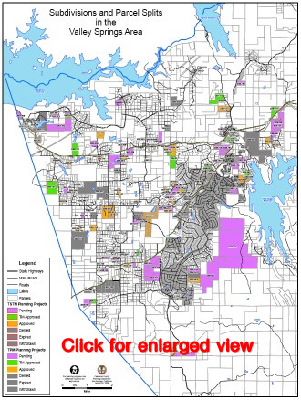
The third map, 'Subdivisions and Parcel Splits in the Valley Springs Area, was done by the Calaveras County Planning Department in August 2009. It also reflects projects withdrawn, denied, and expired (as of that date).
................................................................
Click on the above small map for the full-size map:
‘Valley Springs Area Planned Residential Developments’
................................................................
Click on the above small map for the full-size map:
'Subdivisions and Parcel Splits in Northwest Calaveras County'
................................................................
Click on the above small map for the full-size map:
‘Subdivisions and Parcel Splits in the Valley Springs Area’
For more information, see Projects List page
NOTE: Please contact us if you have new information or corrections to the maps. Thank you!

HOME
About Us
Support & Action
Planning
Current Development
What's Happening
Resources & Links
Contact Us