


STORM WATER & FLOODING
Click here to return to previous page
Click here for more flood photos and flood maps
Planning for Storms
Without careful planning and management, storm water runoff can contribute to flooding of homes and roads, siltation of creeks and rivers, and problems with water quality & contamination.
Interesting Storm Runoff Facts
- There is NO absorption of water into the ground when it is covered with paving. Think of what happens when open space, pastures, woodlands, dirt, or gravel driveways and parking areas are paved over...all that water that would have been absorbed is now turned into sheets of water running across the pavement looking for somewhere to go. It gains speed and volume until it creates a gully, then a small stream, then a swollen creek.
- A moderate storm that dumps 1" of rain produces about 600 gallons of runoff from a roof surface of 1,000 square feet. Imagine the number of rooftops in your community and you can quickly see how much runoff is headed toward the storm drains, picking up pollutants common in urban areas along the way, and headed toward our lakes, streams and rivers.
- Did you know that because of impervious surfaces such as pavement and rooftops, a typical city block generates 9 times more runoff than a woodland area of the same size?
- The increased volumes and flow rates of runoff produced by urban watersheds have a number of harmful effects including flooding and stream erosion. The water flow velocity of runoff over a smooth, impermeable surface such as a road or parking lot is about ten times faster than over a vegetated surface.
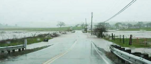
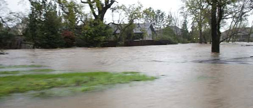
Cosgrove Creek Flooding
Development adjacent to waterways and in flood plains can put public health and safety at risk. Cosgrove Creek runs through Valley Springs and its subdivisions of Gold Creek, La Contenta, and Rancho Calaveras. Some areas are subject to recurrent flooding. This problem has been worsened by poor planning and development decisions in the past, which allowed building and filling in flood plain areas. In April 2006, the creek flooded and damaged approximately 20 homes and businesses. Over 100 other households were evacuated, and sections of Hwy. 26 and Hogan Dam Road were inundated. Flood waters that damaged homes along some areas of Cosgrove Creek were contaminated with untreated sewage.
Click here for flood plain maps and photos of flooding in Valley Springs
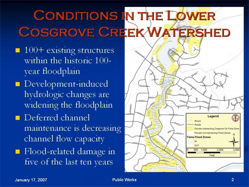
Cosgrove Creek Flood Reduction Study
In 2008, the U.S. Army Corps of Engineers, Calaveras County and CCWD partnered to conduct a flood damage reduction study for Cosgrove Creek. A public meeting was held January 28th, 2009 to gather information and define issues and concerns. Public comments were taken and topics discussed, including: the Corps planning process, Alternative Plans being considered, the NEPA/CEQA process, Timelines, FEMA Mapping, and Permitted Development to date. The Slideshow presentation and Streaming Audio from the January meeting are available on the Public Works website: *Click here for Cosgrove Creek info and meeting presentation*
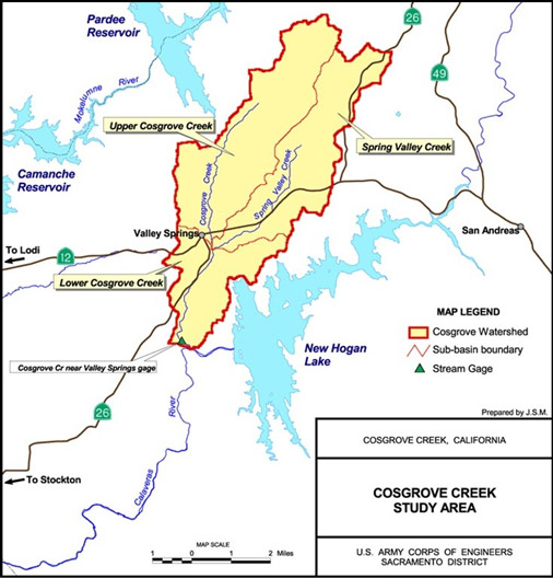
The study is currently in the survey and feasibility process, and is expected to be completed by October 2011. Some flood control improvements (or combinations of improvements) could include elevating buildings along the creek, deepening the creek channel, providing retention and detention basins upstream, raising Hogan Dam Road to create a protective levee, creating a diversion channel to New Hogan Reservoir, and relocating some households and businesses in order to return some areas along Cosgrove Creek back to their natural state.
Storm Water and Grading Ordinances Adopted
Calaveras County adopted new local ordinances regulating storm water quality and grading and drainage in December 2007. Copies of the new ordinances and a ‘Design Manual for Grading, Drainage, and Erosion Control’ are available at the Public Works office or online at their website

HOME
About Us
Support & Action
Planning
Current Development
What's Happening
Resources & Links
Contact Us